Lake
McConaughy, Nebraska
A
Major Drought Continues to Severely Impact The Reservoir
(update
as of June 2006)
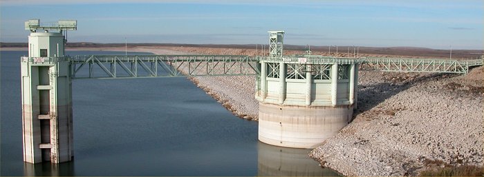
Image
© K. Dewey, High Plains Regional Climate Center. See links to more
photos below.
Kingsley
Dam at Lake McConaughy, Nebraska, November 12, 2004.
NOTE:
The reservoir (lake) is full when the water reaches the level of the horizontal
boom
which
connects the outlet tower on the left and the spillway tower on the right.
The
change in color from light to darker tan along the dam also shows the normal
height of the water.
ALSO
SEE: January
1999 - May 2006 Drought Assessment for Nebraska
ALSO
SEE: June
6, 2006 Drought Update for the Central Nebraska Platte River (includes
photos)
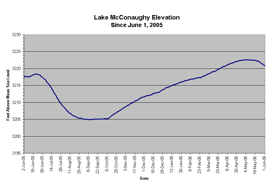
Lake
McConaughy Elevation June 1, 2005 - June 1, 2006
Lake
McConaughy Statistics, June 1, 2005 vs June 1, 2006
| |
June
1, 2005
|
June
1, 2006
|
Difference
|
|
Elevation
|
3217.7 feet
|
3220.9 feet
|
+3.2 feet
|
|
Below max elevation
|
-52.3 feet
|
-49.1 feet
|
+3.2 feet
|
|
% Capacity
|
37.0%
|
40.3%
|
+3.3%
|
|
Volume
|
645,300 acre
ft.
|
702,300 acre
ft.
|
+57,000 acre
ft.
|
| Amount below capacity |
|
|
|
Maximum elevation
is 3270 feet.
maximum volume
(storage) is 1,900,600 acre feet
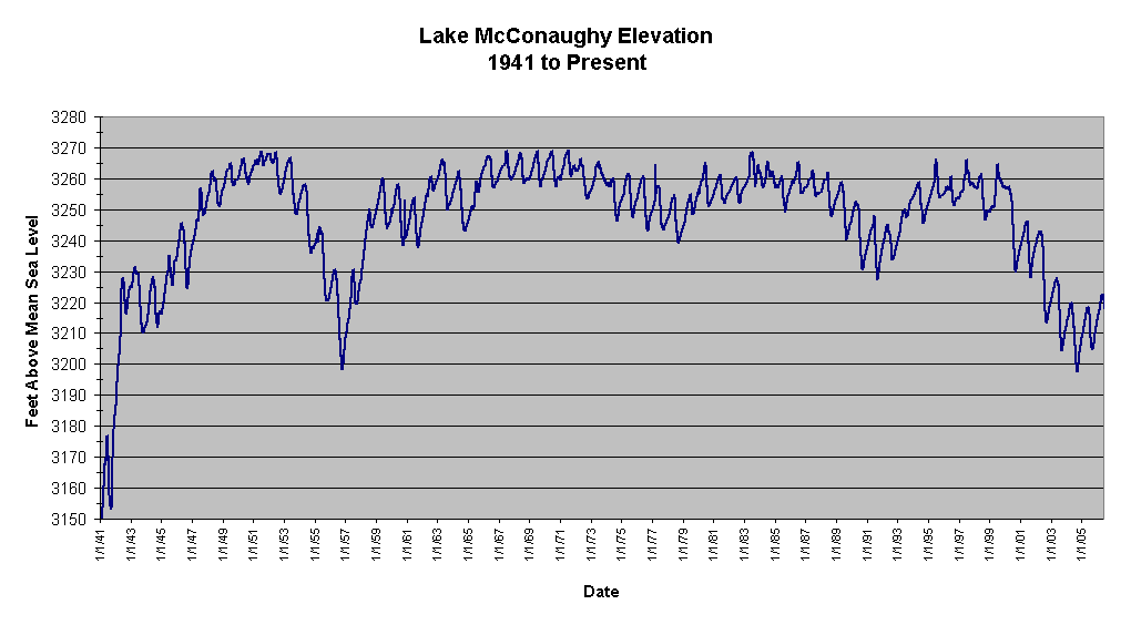
Lake McConaughy Quick Facts:
-
The lake north of Ogallala on the North Platte River is Nebraska
's largest reservoir.
-
It was filled in 1952 after Kingsley Dam's completion in 1941.
-
Lake McConaughy was built for irrigation but it is also popular for
recreation.
-
Lake McConaughy is 22.1 miles long at maximum pool and is 142 feet deep
at maximum depth when full.
-
The Outlet Tower height is 185 feet
high and the Spillway Tower is 172 feet high.
-
The Spillway Tower has 12 gates which are 16 feet high and 22 feet wide.
-
The Outlet tower is used for normal water release (water enters the
tower at the bottom of the reservoir). Water enters the hydroplant
from this tower.
-
The Spillway Tower is used only in the event of very high water and
is a flood control outlet for the reservoir.
-
Kingsley Dam is 162 feet in height, 28 feet wide at the top and 3.1
miles long.
The information source for these data is the Central Nebraska Public
Power and Irrigation District. |
Links
to High Plains Climate Center Information about Lake McConaughy:
Photo
Gallery of Lake McConaughy on November 12, 2004.
Photo
Gallery (November 2004) of the Lost Town of Lemoyne which reimerged from
Lake McConaughy.
Links
to the UNL National Drought Mitigation Center Information:
What
is drought?
Current
Drought Monitor Map
Animation
of Drought Monitor Maps (last 12 weeks)
The following map
shows the lingering drought in most of Nebraska
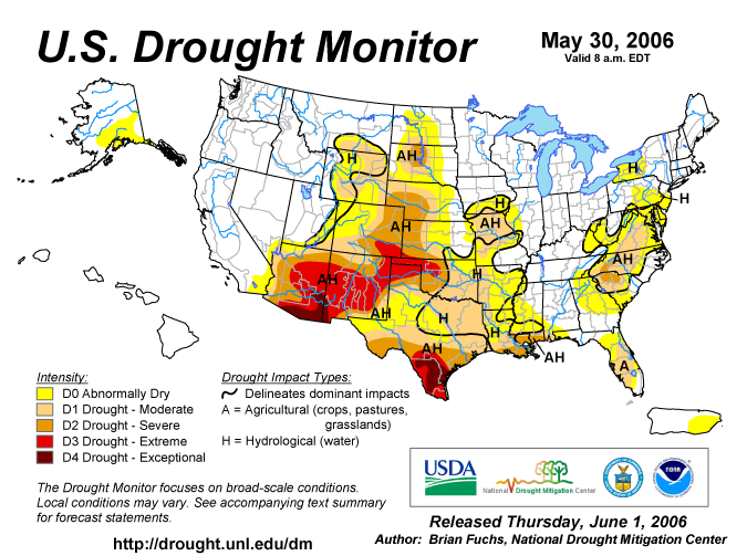
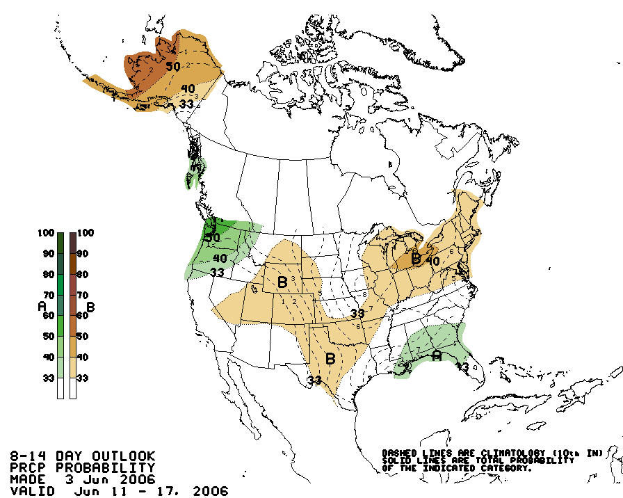
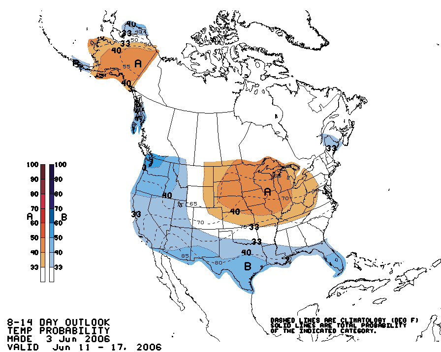
The
Climate Prediction Center Outlooks for mid June show a continuation of
warmer
than
normal and drier than normal conditions for much of the Great Plains.
LINKS:
Central
Nebraska Public Power and Irrigation District
Central
Nebraska Lake Levels
Climate
Prediction Center 8-14 Day Outlooks
Lake
McConaughy
Lake
McConaughy Web Cam
No-till
on the Plains
Nebraska
Public Power District
National
Drought Mitigation Center
Water
Resources Data for the Nation
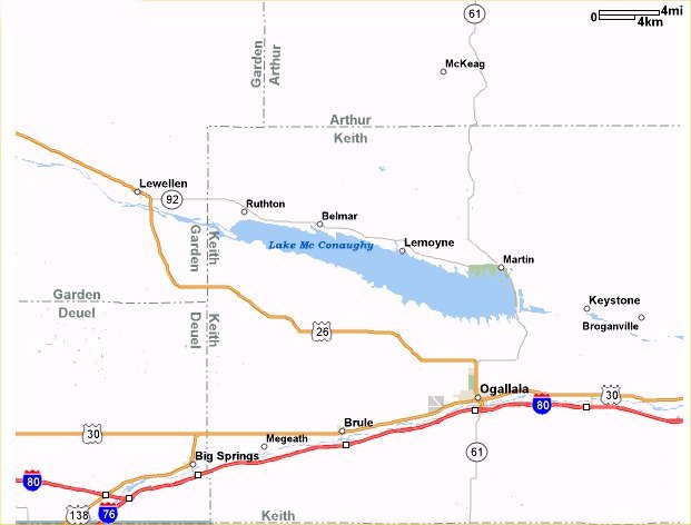
Map
Showing Location of Lake McConaughy Relative to Interstate 80 in western
Nebraska