CLICK HERE FOR THE March 12, 2006 Photo Gallery
CLICK HERE FOR THE March 12, 2006 Photo Gallery
| Killer
Tornadoes Rip Across Midwest -- At Least 10 Deaths Blamed on Violent
Weather
By JOHN MILBURN, AP Breaking News: Authorities say tornadoes killed at least nine people in Missouri. LAWRENCE, Kan. (March 13) - Tornadoes swept through portions of the Midwest, killing at least three people in Missouri, blowing roofs off homes in Illinois and Arkansas, and damaging about 60 percent of the buildings on the University of Kansas campus. A fourth storm death was reported in Indiana. Violent storms continued early Monday in Springfield, Ill., where a tornado also struck Sunday night, taking the roof off of a Wal-Mart. Mayor Tim Davlin said he expected "every square inch of Springfield" will have suffered some effect from the storms. The storms forced the temporary closing of most major roads into the city. One man was reported missing after his home was destroyed; 19 others were treated at local hospitals for tornado-related injuries, authorities said. In Missouri, severe weather was blamed for three deaths, including a woman who was killed Sunday as she tried to seek refuge from a tornado in her mobile home south of Sedalia. Two other people were missing Sunday night and six were injured, officials said. Bobby Ritcheson, 23, said
he watched as his neighbor was killed. "The trailer came down right
on top of her," said Ritcheson, who talked to The Associated Press at a
Sedalia hospital where he had taken his pregnant wife out of concern she
might be going into labor. Tornado sirens sounded at least three
times in Sedalia on Sunday as one storm after another rolled through the
city. The severe weather followed a powerful storm that ripped through
southern Missouri and southern Illinois late Saturday, killing a
married couple whose car was blown off the road and destroying homes along
a path of more than 20 miles south of St. Louis, officials said.
John Gagan, a meteorologist with the National Weather Service in Springfield,
Mo., said there would be no way of knowing the scope of the damage until
Associated Press reporters
F.N. D'Alessio in Chicago, Noah Trister in Bentonville, Ark., David Lieb
in Sedalia, Mo., Garance Burke and Margaret Stafford in Kansas City, and
Jim Salter in St. Louis contributed to this report. 3/13/2006 06:51:33
|
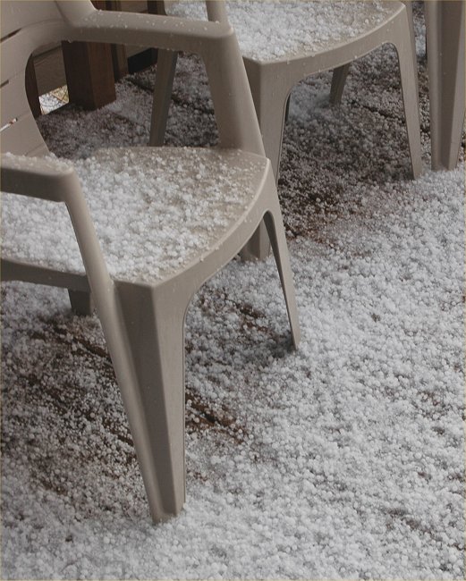
An early morning hail storm passes
over Lincoln
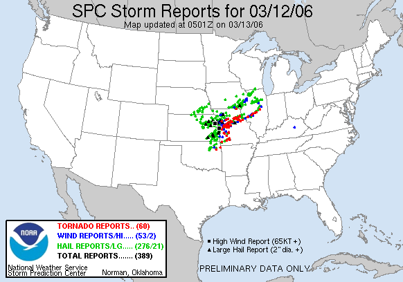
| MESOSCALE DISCUSSION 0253
NWS STORM PREDICTION CENTER NORMAN OK 0709 AM CST SUN MAR 12 2006 AREAS AFFECTED...FAR NERN KS / SERN NEB / NWRN MO CONCERNING...SEVERE THUNDERSTORM POTENTIAL VALID 121309Z - 121445Z POTENTIAL FOR ISOLATED LARGE HAIL IS EXPECTED TO DEVELOP N OF WW 69 BY 14Z...AND A WW MAY BECOME NECESSARY. AS OF 13Z...REGIONAL
RADAR IMAGERY SHOWED A CLUSTER OF ELEVATED TSTMS OVER THE NERN QUARTER
OF KS MOVING 215/40 KTS. SEVERAL REPORTS OF LARGE
HAIL HAVE BEEN RECEIVED WITH THESE STORMS OVER THE PAST COUPLE OF HOURS.
WHILE 12Z TOP SOUNDING INDICATED ONLY A MARGINALLY UNSTABLE AIR MASS /I.E.
MUCAPES OF 500-700 J/KG/ FOR A
THEREFORE...EXPECT THESE ELEVATED STORMS TO CONTINUE TO MOVE AND/OR DEVELOP NEWD INTO PORTIONS OF SERN NEB AND PERHAPS NWRN MO THIS MORNING WITH THE POTENTIAL FOR MARGINALLY SEVERE HAIL. ..MEAD.. 03/12/2006 |
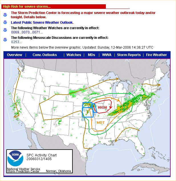
| Public Severe Weather Outlook
PUBLIC SEVERE WEATHER
OUTLOOK
VALID 120946Z - 121745Z ...SEVERE THUNDERSTORM OUTBREAK EXPECTED OVER PARTS OF THE LOWER MISSOURI AND MID MISSISSIPPI RIVER VALLEYS LATER TODAY AND TONIGHT... THE NWS STORM PREDICTION CENTER IN NORMAN OK IS FORECASTING THE DEVELOPMENT OF A FEW STRONG...LONG-TRACK TORNADOES OVER PARTS OF THE LOWER MISSOURI AND MID MISSISSIPPI RIVER VALLEYS LATER TODAY AND TONIGHT. THE AREAS MOST LIKELY TO EXPERIENCE THIS ACTIVITY INCLUDE FAR SOUTHERN IOWA WEST CENTRAL ILLINOIS MISSOURI SURROUNDING THE HIGH RISK AREA...THERE IS A MODERATE RISK OF SEVERE THUNDERSTORMS FROM EASTERN OKLAHOMA AND KANSAS INTO THE MID SOUTH AND OHIO RIVER VALLEY. A VOLATILE SITUATION
IS EXPECTED TO UNFOLD OVER EASTERN PORTIONS OF THE CENTRAL PLAINS AND MUCH
OF THE LOWER MISSOURI...MID MISSISSIPPI AND OHIO RIVER
VALLEYS TODAY AND TONIGHT. A VERY STRONG UPPER LEVEL
THIS IS POTENTIALLY A VERY DANGEROUS SITUATION. THOSE IN THE THREATENED AREA ARE URGED TO REVIEW SEVERE WEATHER SAFETY RULES AND TO LISTEN TO RADIO...TELEVISION...AND NOAA WEATHER RADIO FOR POSSIBLE WATCHES...WARNINGS...AND STATEMENTS LATER TODAY. ..EVANS.. 03/12/2006
|
Return to: March 12, 2006 Photo Gallery