December
22, 2007
A
Major Snowstorm Just Misses Nebraska.
From the National Weather Servce, Pleasant Hill, Missouri
December
22, 2007
A
Major Snowstorm Just Misses Nebraska.
From the National Weather Servce, Pleasant Hill, Missouri
|
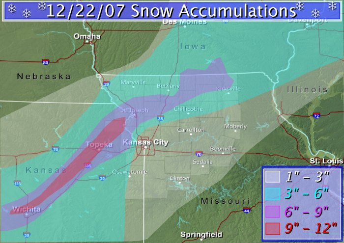
Winter 2007 Ushered in With Style... A large winter storm affected much of the central United States, on most appropriately the first day of winter! The first affects of this winter storm reached the lower Missouri River valley early in the day on the 22nd, when rain, sleet, and freezing rain lifted northward over the area. However, this mixed bag of precipitation quickly transitioned to snow in areas along the I-35 corridor in Kansas and Missouri. Heavy snow was often observed with many rumbles of thunder heard throughout the event. By the evening hours of the 22nd, locations from Wichita northeastward through Topeka, Leavenworth, St. Joseph, Gallatin, Trenton, and Unionville received upwards of 6-9 inches of snowfall! Further to the south and east, a tight snowfall gradient formed, with locations across the Kansas City metropolitan area receiving anywhere from 2-4 inches. Further to the east southeast, freezing rain, sleet, and rain lasted slightly longer through the day, with areas from Clinton to Marshall, and Boonville only receiving 1-3 inches of sleet and snow accumulations. To make matters worse during this winter storm, howling northwesterly winds between 20 and 30 mph created white out conditions across portions of northeastern Missouri and northeastern Kansas. Visibilities were often reduced to feet at times, with widespread snowdrifts approaching 2 or 3 feet. These hazardous conditions caused numerous traffic accidents, including large multi -car accidents in St. Joseph on Interstate 29, and just west of Topeka on Interstate 70. Those Christmas holiday travelings moving northward along Interstate 29 were also stranded during the height of the evebt, as snow and blowing snow caused the closure of Interstate 29 from St. Joseph to the Nebraska border. In addition, skies gradually cleared across the region during the morning of the 23rd, allowing visible satellite imagery to capture the expansive snow field currently across the Midwest. Even though temperatures will try to warm during the next few days, light winds traveling over this expansive snowpack will keep temperatures cool through the work week. |